This is the seventh of a series of
documents that describe the contents of the PLSS CadNSDI data set.
PLSS Special Surveys are non-rectangular PLSS surveys. They are deviations from the hierarchical
rectangular surveys, are often defined or guided by provisions of legislation
or authorities. PLSS Special Surveys can
“sit on top” of rectangular surveys or they may replace the rectangular
surveys, creating a “hole” in the rectangular surveys. In some cases a nominal rectangular survey is
extended through the special surveys.
The PLSS Special Surveys are not populated for the many eastern
states data sets because at the time of the PLSS Surveys in the eastern states,
the non-rectangular survey types had not been well established. Also in the eastern states many of the
non-PLSS areas were defined before the PLSS and were never in the public
domain. However, for purposes of
transition in some of the eastern states PLSS the non-PLSS data are in the PLSS
special surveys, this will update over time.
The other item of note in western states lands that were not in
the public domain, such as Land Grants, is in the PLSS Special Surveys, but may
transition to the Survey System feature class over time.
Each PLSS Special Survey feature or parcel has one survey type
designation. The PLSS Special Survey
parcels may overlap. The attributes for
this feature are listed below.
|
FieldName
|
Type
|
Length
|
Description
|
AliasName
|
|
SURVID
|
String
|
50
|
Unique identifier for a PLSS Special Survey
feature
|
Survey Identifier
|
|
SURVTYP
|
String
|
2
|
Code for the type of special survey.
|
Survey Type Code
|
|
SURVTYPTXT
|
String
|
50
|
Special survey type text description.
|
Survey Type Text
|
|
SURVNO
|
String
|
50
|
Special survey number or designator that
identifies the special survey polygon
|
Survey Number
|
|
SURVSUF
|
String
|
5
|
Special survey suffix designation that makes the
identification of the area unique.
|
Survey Suffix
|
|
SURVNOTE
|
String
|
50
|
Notes about the polygon feature that are
important for using or understanding the feature. From the BLM SurvNotes are
A = Approximate Acreage, C = Conflict or Questionable, D = Non-added Acreage,
R = replaced
|
Survey Note
|
|
SURVDIV
|
String
|
50
|
The name or designation for any division of a
PLSS Special Survey such as Lot in a Tract
|
Special Survey Division
|
|
SURVLAB
|
String
|
50
|
Label that is used for cartographic output or web
display.
|
Survey Label
|
|
RECRDAREATX
|
String
|
20
|
The record or recorded area as a text field. This
may include the units of area as well.
|
Record Area Text
|
|
RECRDAREANO
|
Double
|
8
|
The record or recorded area as a numeric field
|
Record Area Number
|
|
GISACRE
|
Double
|
8
|
The area of the feature in acres - computed from
the GIS, this is not the record area.
|
GIS Area Acres
|
|
SOURCEREF
|
String
|
100
|
The reference to the source document could be a
reference to a map or plat or a deed. This could include document type.
|
Source Doc Link or Reference
|
|
SOURCEDATE
|
Date
|
8
|
The date of the source document
|
Source Doc Date
|
The Survey Identifier is included in
this feature but it is not fully populated in the data sets. The original intent was to define a unique
identifier for each special survey type, for example, most mineral surveys are
uniquely numbered in the state and tracts are uniquely numbered within a PLSS
Township, but this work was not completed in the initial data sets.
The domain of values for the PLSS Special
Surveys is listed below. These codes and
types come from the BLM records system and are used to match the special survey
parcel to federal records. Over time it
is expected that the description will be relied on much more than the codes.
|
Special
Survey Type Code
|
Special
Survey Type Description
|
Notes
|
|
2
|
Tract
- Other than cadastral survey
|
A
tract other than a cadastral survey tract is a piece of land that has the
term tract as its designated land description on a survey document. The lands will typically have a number,
name, or letter designation.
|
|
D
|
Allotment
Survey
|
Allotment
Survey is an allocation of discretionary assignment of lands.
|
|
E
|
Metes
and Bounds
|
Metes
and bounds surveys are required to define the boundaries of irregular areas
of land, which are not conformable to rectangular subdivisions. Metes and
bounds PLSS Special Survey Types are coded as a metes and bound if no other
non-rectangular survey type can be identified.
|
|
F
|
Farm
Unit Survey
|
Farm
Unit Survey
|
|
G
|
Land
Grant
|
A
Land Grant is a portion of land that was claimed and occupied by a foreign
power or government prior to survey.
Land Grants are not the same as Grants of Land made to individuals
prior to survey. Neither the Land
Grant nor Grants of Land are part of the PLSS as the rights to these lands
existed prior to the public land survey.
The boundaries of these lands form a closing line for the PLSS
surveys.
|
|
H
|
Homestead
Entry
|
Homestead
Entry is a metes and bounds survey made under the Homestead Act defining
lands acquired under an entry for the purpose of acquiring title. Homestead Entry Surveys are numbered
sequentially and uniquely within a state.
|
|
I
|
Indian
Interest
|
This
code and domain was originally Indian Allotment but has been expanded in the
standard domains to include all Indian Interest lands including allotments,
reservations, and other lands.
|
|
J
|
Small
Tract, Small Holding Claim
|
The
survey made to delineate the tracts differs from a townsite survey in that it
normally follows a pattern of progression subdivision down to the desired lot
sizes without block designations or the segregation of streets and alleys.
Regulations provide for reserving rights-of-way in the patents or leases.
|
|
M
|
Mineral
Survey
|
A
Mineral Survey is a lode claim, placer claim, or mill site established to
mark the extent of public lands claimed for the development of minerals and
intending to become a private interest.
Not all mineral surveys complete to a patent and those that do not
complete are reverted back to federal ownership in most cases.
|
|
N
|
Townsite
Survey
|
There
are many provisions for the executive withdrawal of public lands for townsite
purposes. A townsite survey is a survey made within one or more regular units
of the township subdivision by which the land is divided into blocks,
streets, and alleys as a basis for the disposal of title in village or town
lots.
|
|
K
|
Townsite
Block
|
A
Townsite Block is a block within a townsite.
The Townsite Block needs the townsite designation to uniquely identify
it.
|
|
Y
|
Townsite
Outlot
|
A
Townsite Outlot is a lot designated for public or community use within a
townsite.
|
|
P
|
BLM
Parcel
|
BLM
Parcel
|
|
Q
|
Donation
Land Claim
|
Donation
Land Claims are portions of land that are 160 or 320 acres in size granted
under the Donation Land Act of 1850 to citizens who resided in the Oregon
Territory. These are not the same as
donation lands that were public lands donated or granted as an incentive for
construction, such as railroad donations.
|
|
S
|
United
States Survey - Alaska Only
|
United
States Surveys exist only in Alaska.
These are similar in form to Townsite Surveys and provide for the
disposal of public lands for occupation and settlement.
|
|
T
|
Tract
|
A
tract is portion of land that protects a bona fide right. Tracts are metes and bounds surveys that
define the perimeter of lands settled between the time of the plan of survey
and the actual field survey.
Settlement occurred following the boundaries intended to be as defined
in the rectangular survey but do not conform to the actual rectangular
survey. Tracts are always contained
within a PLSS Township and PLSS Township lines encompass the tracts. Tracts are numbered within the Township
taking the next highest number available after the highest section
number.
|
|
X
|
Exchange
|
An
exchange survey is a portion of land that has been described to support the
exchange of private lands and public lands.
These are metes and bounds surveys.
|
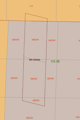
The image below shows a cluster of
mineral surveys and the surrounding rectangular lots and aliquot parts
 |
| Mineral Surveys and Rectangular Surveys |
This same area without the special
surveys appears to have “hole” in the second division. This same “hole” will not be apparent in the
Township and first division, at least for the mineral surveys.
 |
| "Hole" in Rectangular Survey |
In other cases the non-rectangular
surveys will sit “one top” of the rectangular surveys and the rectangular
portions will continue under the special surveys.
 |
| Rectangular Areas Under Special Survey |
The image below shows a Tracts and PLSS first
divisions (Sections).
 |
| Tracts and Sections |
The Tracts are non-rectangular parcels
that typically start with number 37 in a township to distinguish them from
sections. Technically, Tracts are metes
and bounds surveys that delineated lands that have an established right
established prior to the rectangular survey typically by occupation. This occurs when the land was settled prior
to survey and the occupants intended to occupy a section or other parcel of
land described from an unsurveyed plat.
When surveyed measurements of the protected rights determined that the
occupied land did not conform to the rectangular survey, a tract is
defined. By definition the tract is described
by PLSS Township and the Tract number. The
PLSS Township boundary should encompass the outside boundary of the tract. However, this can create a “notch” or
“protrusion” on the township boundary and in some cases the theoretical
township line is extended through the tract.
Tracts numbering begins with the number 37. In the image above Tracts 38
to 40 are PLSS special surveys.
Another PLSS Special Survey is the
Townsite, coded as special survey type N in BLM records. The polygons labeled in the figure below as
“K ##” are the Townsite blocks, special survey type code K in BLM records. In the PLSS a Townsite survey is a special
survey that divides the land into blocks, lots, streets, alleys, rights of way,
and reservations forming land descriptions for the disposal of title. The key word is disposal. Townsites, through a variety of acts and
authorities, are intended to pass the land from federal to private
ownership. However, there may be parts
of Townsites that remain in federal ownership or are re-acquired back to
federal ownership.
 |
| Townsite Survey |
In this case the roads (coded as
Townsite survey) plus the Townsite blocks would form the complete Townsite
survey.
There are many other types of
non-rectangular surveys in the public domain and each will have a designated
authority and survey rules. Not all
special surveys are found in all states.
It is best to consult with the state BLM Office or the state data
steward for special survey situations that are irregular or not clear in the
PLSS CadNSDI data sets.


