Thursday, December 19, 2013

Add WFS to ArcGIS Arc Map Canvas

Adding Web Feature Services (WFS) to ArcMap is a useful process if you want to find and add data that is not on ArcGIS Online or data that is only provided as a feature service and not a web service or REST service.  The WFS drawing and access may be slightly slower than other service access, so be aware of the number of features and the scale of the display.  The advantage is the data is provided as features and can be manipulated as features.

Adding a Parcel WFS with Parcel GML to ArcGIS desktop is a six step process.

Step 1 - Install Data Interoperability Functionality

The data interoperability extension has to be installed on your desktop but it does not have to be licensed.  To install the extension without purchasing it or going through the set up that requires a license requires the following steps.

Find the DVD with the ArcGIS Media.  This may be a virtual drive, if it is, mount the virtual drive to access the data interoperability set up.  When you open either the virtual drive or the physical media, a standard Esri install/set up screen displays.  Don’t use this route.  Open the drive in windows explorer and find the DataInterop folder.  In that folder is a set up application.  Run the set up application (not the set up configuration settings or the set up windows installer). Accept the licensing terms and select an installation folder, just like normal installs.

When you open Arc Catalogue the Interoperability Connections will appear in the list of potential connections as shown in Step 1 below.  There is no need to customize the extension since this activation will require a paid up license.

 Step 2 – Add WFS Service to Interoperability Connections

Open Arc Catalog and expand the Interoperability Connections.
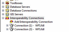
Step 3 – Select Add Interoperability Connection

Select WFS from the format selection box and enter the service URL as shown in the Dataset window below.  This example is the federal land ownership WFS from the State of New Mexico.  One tip is to let the service determine the Reader Format.


Step 4 – Set Parameters

There are several parameters for the service that can be set by hand.  In this example the number of features was constrained to 30,000 to increase the speed performance.  The next two screens show the parameters.


Verify the connection by selecting the preview tab in Arc Catalogue.


Step 5– Rename the Connection (Optional)

The connection can be renamed so it can be easily identified when adding it to a Map Document.


Step 6 – Add Data to Map Document

In ArcMap Select Add Data.  Navigate to the Interoperability Connection in the Look in: pull down and double click on the feature class.  In this case the Fed-Lands-New-Mexico.


Select the Fed-Lands-New-Mexico.fdl (expand the database symbol to see the feature class).


Click on the Feature and then the Add button. The feature will index as it adds.

The Federal Lands GML features are now available on your active ArcGIS canvas.  If the ArcGIS map document is saved, each time the map document is opened the service will access the most current Fed Lands from New Mexico GML data available from the WFS.
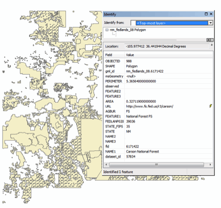


The data from the WFS can be filtered by time stamp, by feature attribute, and symbolized, queried, and used in the desktop just as any other locally source data.


Wednesday, September 18, 2013

Eminent Domain Solution for the Mortgage Crisis


Here is an interesting approach to the mortgage crisis.  What if your city was severely affected by the mortgage crisis with many homes going into foreclosure and the resulting property tax revenues plummet, putting your entire city into a downward cycle?  And what if your city determined that the mortgage crisis was a major threat to survival of the city?

If an earthquake, a flood, a hurricane, or some other natural disaster struck this same city, the city could make a disaster declaration and apply for low cost loans, a Stafford Act request could be made for support, and the city might be able to recover.  The Stafford Act applies to natural disasters.

“It is the intent of the Congress, by this Act, to provide an orderly and continuing means of assistance by the Federal Government to State and local governments in carrying out their responsibilities to alleviate the suffering and damage which result from such disasters.  “Emergency” means any occasion or instance for which, in the determination of the President, Federal assistance is needed to supplement State and local efforts and capabilities to save lives and to protect property and public health and safety, or to lessen or avert the threat of a catastrophe in any part of the United States” 

Richmond California is taking another approach and have adopted a plan to invoke the powers of eminent domain to acquire mortgages that are under water and then to find lower priced options for the homeowners to keep them in their homes, to keep the real estate tax payments stable, and to stop the downslide.   The Federal Housing Finance Agency is opposed to this approach and has stated it would suspend Fannie Mae and Freddie mac business in the city if this were invoked.  (http://www.reuters.com/article/2013/09/11/us-richmond-eminentdomain-idUSBRE98A0FN20130911)

A lawsuit by mortgage companies to stop the city from executing its plan has “not ripened” according to a U.S. District Court.

There was a nice National Public Radio (NPR) piece on this issue on September 17, 2013.  (http://www.nonprofitquarterly.org/policysocial-context/22911-eminent-domain-proposal-in-richmond-ca-advances.html)  The organizing for and against is particularly interesting. Opponents of the eminent domain plan rounded up local college kids, gave them red “a bad deal for Richmond” T-shirts, and had them wave “stop investor greed” placards, while supporters handed out yellow T-shirts with “yes on Richmond CARES” stickers. But the opposition is also lined up in court. For the last few months, Wall Street has traipsed into federal court threatening all kinds of problems for the city, led by filings by Wells Fargo and Deutsche Bank, and they have been joined by a surprising ally: the Federal Housing Finance Agency, which oversees and regulates Fannie and Freddie. MRP is willing to foot Richmond’s legal bills, but won’t indemnify the city if the courts rule against it and exact costly penalties. A small coalition of nonprofits, however, including the California Reinvestment Coalition, the National Housing Law Project, Housing and Economic Rights Advocates, Bay Area Legal Aid, and the Law Foundation of Silicon Valley, has filed an amicus against Richmond’s Wall Street adversaries.

The mortgage crisis and approaches to solutions drive home the importance of parcel information, the real estate tax systems, being able to monitor and perform analysis on the economy of parcel data in any jurisdiction.  Regardless of how this is settled or resolved, parcel data will be essential to track the conditions, monitor progress, and provide measurable indicators for success.


Thursday, September 5, 2013

Parcel Index

Parcel Index

(This is patterned after the Harper Indexpublished each month in Harpers magazine)

There are approximately 12,000 real estate assessing jurisdictions in the US.

This is about 26,000 people and about 13,000 parcels per assessing jurisdiction.

In Michigan there are approximately 5,000 people and about 2,500 parcels per assessing jurisdiction.

Virginia has 138 real estate taxing jurisdictions.

There are over 6,000 real estate taxing jurisdictions in the US.

There are approximately 150,000,000 tax parcels in the US and approximately 313,000,000 people, averaging about 2 people per parcel.

Slightly over 90% of the tax parcels in the US have been mapped in a computer mapping system.

About 94% of the US lives in a jurisdiction that has digital parcel data.

Approximately 75% of the counties in the US have digital parcel mapping systems.

Approximately 50 apps related to parcel data are in the iTunes store, not all of them US based.

The Public Land Survey System (PLSS) covers 30 states in the US.

Manta lists 181,848 companies with land surveying in their name, 242, 658 with Land Information in their name, and 67,045 with Geographic Information in their name in the US. 

RealtyTrac estimates there were 130,888 new foreclosures in July 2013 with an average sale value of $164,971.

RealtyTrac estimates that there are currently 1,305,081 properties in US that are in some stage of foreclosure (default, auction, or bank owned).


According to the Census there were 132,419,000 housing units in the US in 2011. Approximately 114,907,000 were occupied as regular residences and 17,512,000 were vacant or seasonal.


The assessment jurisdiction numbers come from the International Association of Assessing Officers (http://www.iaao.org), the parcel counts come from the national parcel inventory (http://www.bhgis.org/inventory/) data set, Manta can be found at (http://www.manta.com/), RealtyTrac can be found at (http://www.realtytrac.com/), and the US Census Bureau is at (http://www.census.gov/).  Harper's Index can be found at (http://harpers.org/harpers-index/)

Friday, August 16, 2013

Parcel Data Sharing and Ice Cream

The discussions about open data sharing, interoperability, and web services continue to build.  FGDC has published a new portal and there are new open cloud services every day.  What strikes me in these discussions is that at some level we are still resolving data content issues. 

Consider this scenario.  What if parcel data producers, mostly local governments in the U.S. and about 6,000 different local governments, made ice cream instead of parcel data.  Almost everyone loves ice cream but few understand the challenges of making large batches of consistent texture, predictably flavored ice cream.  Locally made ice cream would reflect local tastes and preferences and would evolve with the local needs and demands.

Complicating things is each state would have rules for ice cream packaging, pricing, butter fat content, and maybe even the wafers that could be used for making ice cream cones.  

Vanilla

A consumer might think it is a simple enough question, “I would like some vanilla ice cream.”  The ice cream maker knows there are dozens and dozens of vanilla flavors from plain vanilla to French vanilla with variations including premium churned, fat free, egg free, extra creamy, triple vanilla and many others.  This does not include the branded names for vanilla, which might be New York vanilla, West Coast California vanilla, and Wisconsin true vanilla. 

The mix of the base ice cream, it’s composition, fat content, churning method, and other processing variations plus the vanilla flavoring itself adds much variation and nuance.  For example “natural flavoring” is castoreum, which is a secretion from the castor sacs of adult North American beavers.  “Real vanilla” comes from a Mexican orchid and from subspecies in Madagascar, the West Indies and South America.

Why is it so hard to just get a national vanilla ice cream based on the locally produced ice cream? 

The local ice cream makers who understand the highly nuanced and local needs find it hard to even find the words to explain the variations in vanilla much less the other flavors and types of ice cream cones that are found across the nation.

With over 6,000 producers across the country, it is not unexpected that there are many variations and nuances.  A simple request for a vanilla ice cream cone has many options, so does requesting parcel information. 

The Business Case for a Publication Standard

The purpose of a publication standard is to describe the business uses and needs to support defined applications.  The publication standard is not a random set of features and attributes. In the ice cream example every producer will have variations in vanilla and a host of other flavors but it is unlikely that every producer will have the same combination of flavors.  The publication standard provides a standard data request that each producer completes as best they can.

The publication standard educates the business user as well as the data producer.  It provides a way for the data producer to understand why and how data are used, it limits the number of data elements the data steward has to publish, and it makes the highly variable and highly nuanced operational data easier for the data requester to understand. 

This point was made in the Fair and Equitable article  “Sharing the Data You Have - Getting the Data You Need”, William Craig and Nancy von Meyer, February 2009 p 9.

“Applications that need parcel data but do not understand the finer points of parcel information cannot distinguish between taxable value and market value, much less decipher which value in the local data set contains the necessary value information.”

The National Cadastral Parcel Publication Standard

The Federal Geographic Data Committee (FGDC) Cadastral Subcommittee has a fairly in depth content standard for cadastral data.  It defines the components of land descriptions, cadastral reference systems, legal measurements, corner monumentation, corner coordinate values, rights and interests, and restrictions to rights and interests.  The content standard provides a checklist of information that could be included in a cadastral data system, but it is not an implementation standard and it is not a publication standard. 

Recognizing that the path to implementation required building a publication standard or guideline, the Subcommittee examined several critical national business uses including hurricane and wildland fire response and recovery, economic and mortgage monitoring and response, and energy development and reclamation.  These were business uses that existed across the country and could be used to define a starting national publication guideline.  Each state could add to this base guideline, but a starting base was seen as one path to increased standard implementation.


The resulting guideline includes components for cadastral reference information (Public land Survey System, land Grants, Subdivisions etc.) and parcel information (real estate tax parcels and coming soon federally managed land parcels).   The publication guideline or standard is not intended to be a burden to data stewards, it is intended to enhance communication and encourage the use of this valuable data set in business applications.